 |
| Huge and mildly terrifying list of issues so far reported at petrochemical facilities after |
Friday, September 1, 2017
Thursday, August 31, 2017
Calculating Harvey’s Aftermath ~Leah Binkovitz, Urban Edge
~The disaster is shaping up to be one of the costliest yet, after hitting the fourth largest city with the second busiest port in the country. It also hit the Coastal Bend area particularly hard, including Port Aransas, caused flooding in Beaumont and Port Arthur and made landfall again in Louisiana. Read more.
Louisiana shelters hundreds of Harvey evacuees from Texas, prepares for more ~Eliazbeth Crisp, The Advocate *
Wednesday, August 30, 2017
Harvey makes landfall again, Texas death toll mounts from record floods ~Reuters
Why Ordinary Citizens Are Acting as First Responders in Houston ~The Atlantic
~The ethos behind these efforts is straightforward and admirable: Some people are in trouble, and other people have the tools to help them. Why wouldn’t they? Clyde Cain, who runs a Cajun Navy Facebook page told USA Today last year, “The reality of the Cajun Navy is everybody out here with a boat that isn’t devastated gets out and helps others.” Read more
~Cajun Navy volunteers attacked in Houston while helping Harvey victims ~Houston Chronicle
How to salvage flood-damaged artwork, books and photographs
'Unseen Dangers' of Harvey: Petrochemical Plants Release 1 Million Pounds of Harmful Air Pollution ~Lorraine Chow, EcoWatch
*
Why Ordinary Citizens Are Acting as First Responders in Houston ~The Atlantic
 |
| Photo: Jon Bridgers, Houston Chronicle |
~Cajun Navy volunteers attacked in Houston while helping Harvey victims ~Houston Chronicle
How to salvage flood-damaged artwork, books and photographs
'Unseen Dangers' of Harvey: Petrochemical Plants Release 1 Million Pounds of Harmful Air Pollution ~Lorraine Chow, EcoWatch
*
Tuesday, August 29, 2017
Harvey Moves Back Over Water; Historic Rainfall Will Continue ~Dr. Jeff Masters, Weather Underground
~When we first saw the model predictions last week of widespread rain amounts for Houston of 15 – 25 inches, with some amounts as high as 40 inches, we issued the required “Catastrophic rains coming” forecast, but our view of the forecast was tinged with a sense of unreality. Could the models be wrong? What would that kind of rainfall would do to Houston? Surely the heavy rains wouldn’t center directly over the nation’s fourth-largest city, would they? But they did. Here we are, in the midst of a mega-disaster on the scale only surpassed by Hurricane Sandy and Hurricane Katrina in recent decades, from a hurricane hazard we’ve never seen on such a large and destructive scale—torrential rain. The damages from Harvey will undoubtedly run into the tens of billions of dollars, making Harvey’s rains the most destructive ever experienced from a hurricane. Read more.
*
Monday, August 28, 2017
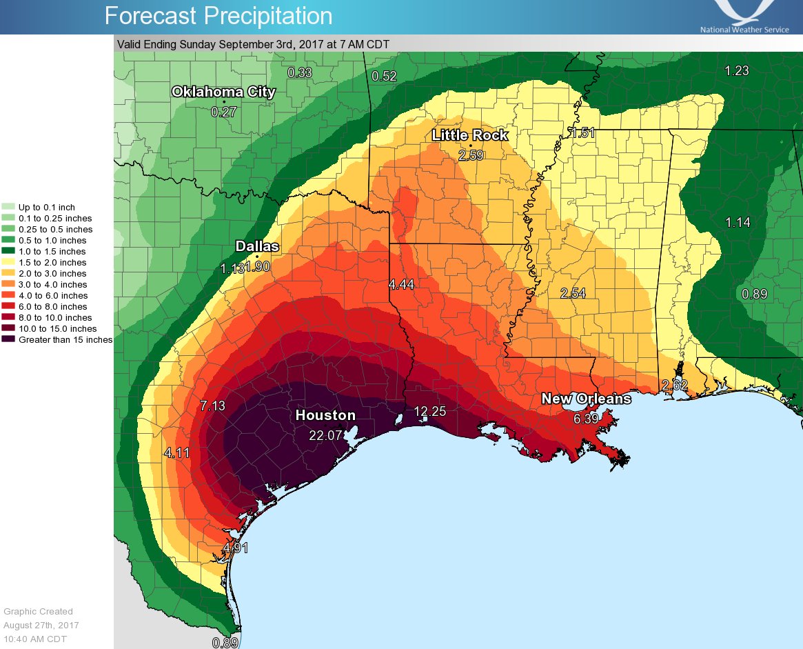
Harvey's 2-day rain in Houston is 3 times floodwater pumped from New Orleans after Katrina ~Nola.com
~For the 48 hours ending at 11 a.m. Monday (Aug. 28), Harris County, Texas, which includes Houston, measured an average 23.7 inches of rain, which represents 732 billion gallons of water, said Jeff Lindner, a Harris County Flood Control District official. While sort of an apples to oranges comparison, that's almost three times as much floodwater as was pumped out of New Orleans in the aftermath of Hurricane Katrina in 2005 by the Army Corps of Engineers.
~For the 48 hours ending at 11 a.m. Monday (Aug. 28), Harris County, Texas, which includes Houston, measured an average 23.7 inches of rain, which represents 732 billion gallons of water, said Jeff Lindner, a Harris County Flood Control District official. While sort of an apples to oranges comparison, that's almost three times as much floodwater as was pumped out of New Orleans in the aftermath of Hurricane Katrina in 2005 by the Army Corps of Engineers.

Flood Calamity Continues In Houston and Beyond; Harvey Edges Toward Coast ~Bob Henson, Weather Underground
 ~The nation’s worst flood disaster since Hurricane/Superstorm Sandy
continued to unfold late Sunday across Houston and nearby parts of
southeast Texas, as Tropical Storm Harvey
punished the area with record-shredding rainfall. As of 6:00 pm CDT
Sunday, Harvey was centered about 10 miles northeast of Victoria, TX,
moving southeast toward the coast at a mere 3 mph with top sustained
winds of 40 mph. Despite its minimal tropical-storm-strength winds,
Harvey is a superpowered rain producer. Parts of the Houston area have
racked up 20” or more in torrential rainbands since Saturday; another
10” – 20” or more is expected, with flooding expanding into parts of
southwest Louisiana. The National Weather Service has kept the Houston
area in a Flash Flood Emergency
since Saturday night—a truly unparalleled stretch—and a Civil Emergency
has been declared. And as if we needed any more trouble, a Tropical Storm Watch has been issued for the North Carolina coast as newly
designated Potential Tropical Cyclone 10 threatens to strike as Tropical
Storm Irma on Tuesday. Read more
~The nation’s worst flood disaster since Hurricane/Superstorm Sandy
continued to unfold late Sunday across Houston and nearby parts of
southeast Texas, as Tropical Storm Harvey
punished the area with record-shredding rainfall. As of 6:00 pm CDT
Sunday, Harvey was centered about 10 miles northeast of Victoria, TX,
moving southeast toward the coast at a mere 3 mph with top sustained
winds of 40 mph. Despite its minimal tropical-storm-strength winds,
Harvey is a superpowered rain producer. Parts of the Houston area have
racked up 20” or more in torrential rainbands since Saturday; another
10” – 20” or more is expected, with flooding expanding into parts of
southwest Louisiana. The National Weather Service has kept the Houston
area in a Flash Flood Emergency
since Saturday night—a truly unparalleled stretch—and a Civil Emergency
has been declared. And as if we needed any more trouble, a Tropical Storm Watch has been issued for the North Carolina coast as newly
designated Potential Tropical Cyclone 10 threatens to strike as Tropical
Storm Irma on Tuesday. Read more
Hurricane Harvey: How to help victims of the Texas storm ~Chron.com
Oil markets roiled as Harvey hits U.S. petroleum industry ~Ahmad Ghaddar, Reuters
~Texas is home to 5.6 million barrels per day (bpd) of refining capacity, and Louisiana has 3.3 million bpd. Over 2 million bpd of refining capacity was estimated to be offline as a result of the storm. Read more.
*
Sunday, August 27, 2017
Tropical Storm Harvey: Live updates as 'catastrophic' flooding swamps Houston ~Nola.com
NWS @NWS This event is unprecedented & all impacts are unknown & beyond anything experienced. Follow orders from officials to ensure safety.#Harvey
Chief Art Acevedo @ArtAcevedo have reports of people getting into attic to escape floodwater do not do so unless you have an ax or means to break through onto your roof #Harvey
*
NWS @NWS This event is unprecedented & all impacts are unknown & beyond anything experienced. Follow orders from officials to ensure safety.
Chief Art Acevedo @ArtAcevedo have reports of people getting into attic to escape floodwater do not do so unless you have an ax or means to break through onto your roof #Harvey
*
Catastrophic, Historic Flooding Happening Now in Houston, Death Toll Rising in Harvey ~Weather Channel
~Thousands of homes are taking on water and hundreds of people are trapped and stranded in rising floodwaters across the Houston metro after Harvey dumped more than two feet of rain. More than 1,000 people have been rescued across the area so far as the death toll from Harvey rose to six.
~~Harvey Mangles Rockport, Texas: 'I've Never Seen Anything Like It'
Houston resident urged to climb to their roofs
Residents at epicenter of Harvey's landfall return to heartbreaking devastation
 @liprap Retweeted @BradDriverKHOU
~Thousands of homes are taking on water and hundreds of people are trapped and stranded in rising floodwaters across the Houston metro after Harvey dumped more than two feet of rain. More than 1,000 people have been rescued across the area so far as the death toll from Harvey rose to six.
“There is life-threatening, catastrophic flooding
happening now in Southeast Harris County,” Jeff Lindner of the Harris
County Flood Control District told The Weather Channel.
Five
people have died in the Houston area in unconfirmed flood-related
deaths as torrential rain continues to fall, according to the National
Weather Service.
 |
| Harvey from the ISS, image credit: NASA/Getty |
Houston resident urged to climb to their roofs
Residents at epicenter of Harvey's landfall return to heartbreaking devastation
The poor Waugh Ave bat colony...
Saturday, August 26, 2017
Harvey Impacts Underway in Houston, Galveston: Hundreds of Thousands Without Power ~Weather Channel
Almost 300,000 are without power and possible tornado damage was reported in cities near Houston Saturday as heavy rain and strong winds from Harvey continued to threaten the area with dangerous flooding.
Heavy rainfall and gusty winds will persist in the Houston area through at least Monday, according to weather.com meteorologist Linda Lam. Rainfall totals of 15 to 30 inches are expected, with locally up to 40 inches possible through midweek. This amount of rainfall brings a serious concern of catastrophic and life-threatening flooding.
The storm left at least one dead in Rockport Friday night. A man was killed when his home caught on fire during the height of the storm. Read more
Why storm experts are so scared about Hurricane Harvey’s rain ~Brian Resnik, Vox
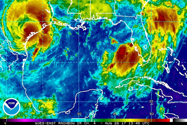
And, it’s kind of mind-boggling. So I called up Hal Needham to help put in in perspective. Needham is a scientist (a geographer by training) and consultant who studies storm surge risk. He’s based in Galveston, Texas, and writes about storm surge science on his blog. He says when a storm like Harvey comes along, we tend to think too simply about storm risk: We fixate on wind speed, or storm surge height, or rain. But what makes this particular storm risky (and complex) is how all those elements mix together. Read more
Hurricane Harvey is a huge, life-threatening storm.
It struck the Central Texas coast Friday night and brought with it 130
mph winds and several feet of storm surge. But perhaps more concerning
is the rain still to come.
“Catastrophic and life-threatening flooding is expected
across the middle and upper Texas coast from heavy rainfall of 15 to 30
inches, with isolated amounts as high as 40 inches, through Wednesday,”
the National Hurricane Center reports in its forecast. That’s almost an entire year’s worth of rain over the course of a few days.
 | |
| Hat Tweet for above graphic: Jeffrey Ray @cbs11jeffrey |
And, it’s kind of mind-boggling. So I called up Hal Needham to help put in in perspective. Needham is a scientist (a geographer by training) and consultant who studies storm surge risk. He’s based in Galveston, Texas, and writes about storm surge science on his blog. He says when a storm like Harvey comes along, we tend to think too simply about storm risk: We fixate on wind speed, or storm surge height, or rain. But what makes this particular storm risky (and complex) is how all those elements mix together. Read more
*
Friday, August 25, 2017
Intensifying Harvey On Track to Hit Texas as Major Hurricane ~Bob Henson, Weather Underground
Sandbags are available to be picked up from 9a-5p until further notice @ Elysian Fields Ave & I-610 and Broad St & Poydras St
GCOOS: Gulf of Mexico Coastal Ocean Observing System
*
Thursday, August 24, 2017
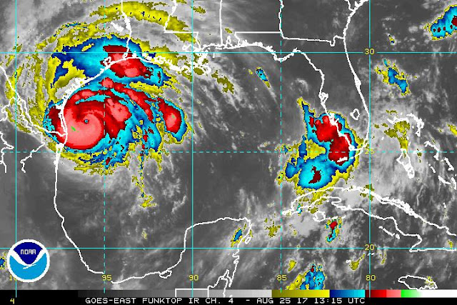
Dangerous, Rapidly Intensifying Harvey Expected to be a Major Hurricane ~Dr. Jeff Masters, Wunderground
Now that Harvey has a well-formed structure, I don’t see any impediments to it intensifying right up until landfall. I expect Harvey will be a Category 2 hurricane by Friday morning and a Category 3 hurricane by Friday night. Harvey probably does not have enough time to become a Category 4 storm, though we cannot rule that possibility out yet.
The current favorable conditions for development will remain in place through Friday night, according to the 12Z Thursday run of the SHIPS model. Wind shear will remain light to moderate, and the atmosphere will be moist. SSTs will remain near 30°C (86°F), and warm waters will extend to considerable depth, with a total ocean heat content of 50 – 80 kilojoules per square centimeter. From Thursday night into Friday, Harvey will get an extra boost in energy as it passes over a warm-core eddy that broke off from the Loop Current. The oceanic heat content within the eddy exceeds 75 kilojoules per square centimeter, enough to support rapid intensification. However, the heat content of this eddy is not as high as the heat content available to Hurricane Katrina of 2005, when it moved over a similar warm-core eddy.
This morning’s runs of our top intensity models—the HWRF, LGEM, COAMPS-TC, and DSHIPS—all predicted a Category 2 or 3 hurricane at landfall. Read more.
*
Now that Harvey has a well-formed structure, I don’t see any impediments to it intensifying right up until landfall. I expect Harvey will be a Category 2 hurricane by Friday morning and a Category 3 hurricane by Friday night. Harvey probably does not have enough time to become a Category 4 storm, though we cannot rule that possibility out yet.
The current favorable conditions for development will remain in place through Friday night, according to the 12Z Thursday run of the SHIPS model. Wind shear will remain light to moderate, and the atmosphere will be moist. SSTs will remain near 30°C (86°F), and warm waters will extend to considerable depth, with a total ocean heat content of 50 – 80 kilojoules per square centimeter. From Thursday night into Friday, Harvey will get an extra boost in energy as it passes over a warm-core eddy that broke off from the Loop Current. The oceanic heat content within the eddy exceeds 75 kilojoules per square centimeter, enough to support rapid intensification. However, the heat content of this eddy is not as high as the heat content available to Hurricane Katrina of 2005, when it moved over a similar warm-core eddy.
This morning’s runs of our top intensity models—the HWRF, LGEM, COAMPS-TC, and DSHIPS—all predicted a Category 2 or 3 hurricane at landfall. Read more.
 |
| Tropical Storm Harvey as seen by the GOES-16 satellite at 10:15 am CDT Thursday, August 24, 2017. Image credit: NOAA/CIRA/RAMMB. NOAA’s GOES-16 satellite has not been declared operational and its data are preliminary and undergoing testing |
Tuesday, May 2, 2017
Wednesday, March 29, 2017
Wednesday, March 1, 2017
Thursday, February 23, 2017
Wednesday, February 8, 2017
Tuesday, February 7, 2017
Sunday, January 29, 2017
Wednesday, January 25, 2017
Monday, January 23, 2017
Major expansion of surveillance cameras in French Quarter, 20 hot spots plus new 3 a.m. rule for bars ~Jeff Adelson, N.O. Advocate
Louisiana police chief pushes ‘Blue Lives Matter’ law to make resisting arrest a felony ‘hate crime’ ~Erin Corbett, Raw Story
To Fight Coastal Damage, Louisiana Parishes Pushed To Sue Energy Industry ~Tegan Wendland, WWNO
Coyote wanders onto Frenchmen Street, seeks refuge at Dat Dog ~Wilborn P. Nobles III
Thursday, January 19, 2017
Wednesday, January 18, 2017
Sunday, January 15, 2017
Friday, January 13, 2017
Thursday, January 12, 2017
Subscribe to:
Posts (Atom)