Saturday, August 26, 2017
Harvey Impacts Underway in Houston, Galveston: Hundreds of Thousands Without Power ~Weather Channel
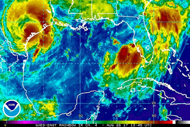
Almost 300,000 are without power and possible tornado damage was reported in cities near Houston Saturday as heavy rain and strong winds from Harvey continued to threaten the area with dangerous flooding.
Heavy rainfall and gusty winds will persist in the Houston area through at least Monday, according to weather.com meteorologist Linda Lam. Rainfall totals of 15 to 30 inches are expected, with locally up to 40 inches possible through midweek. This amount of rainfall brings a serious concern of catastrophic and life-threatening flooding.
The storm left at least one dead in Rockport Friday night. A man was killed when his home caught on fire during the height of the storm. Read more
Why storm experts are so scared about Hurricane Harvey’s rain ~Brian Resnik, Vox
And, it’s kind of mind-boggling. So I called up Hal Needham to help put in in perspective. Needham is a scientist (a geographer by training) and consultant who studies storm surge risk. He’s based in Galveston, Texas, and writes about storm surge science on his blog. He says when a storm like Harvey comes along, we tend to think too simply about storm risk: We fixate on wind speed, or storm surge height, or rain. But what makes this particular storm risky (and complex) is how all those elements mix together. Read more
Hurricane Harvey is a huge, life-threatening storm.
It struck the Central Texas coast Friday night and brought with it 130
mph winds and several feet of storm surge. But perhaps more concerning
is the rain still to come.
“Catastrophic and life-threatening flooding is expected
across the middle and upper Texas coast from heavy rainfall of 15 to 30
inches, with isolated amounts as high as 40 inches, through Wednesday,”
the National Hurricane Center reports in its forecast. That’s almost an entire year’s worth of rain over the course of a few days.
 | |
| Hat Tweet for above graphic: Jeffrey Ray @cbs11jeffrey |
And, it’s kind of mind-boggling. So I called up Hal Needham to help put in in perspective. Needham is a scientist (a geographer by training) and consultant who studies storm surge risk. He’s based in Galveston, Texas, and writes about storm surge science on his blog. He says when a storm like Harvey comes along, we tend to think too simply about storm risk: We fixate on wind speed, or storm surge height, or rain. But what makes this particular storm risky (and complex) is how all those elements mix together. Read more
*
Friday, August 25, 2017
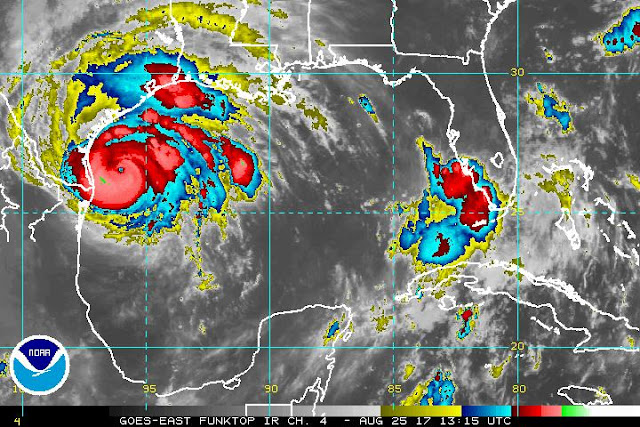
Intensifying Harvey On Track to Hit Texas as Major Hurricane ~Bob Henson, Weather Underground
Sandbags are available to be picked up from 9a-5p until further notice @ Elysian Fields Ave & I-610 and Broad St & Poydras St
GCOOS: Gulf of Mexico Coastal Ocean Observing System
*
Thursday, August 24, 2017
Dangerous, Rapidly Intensifying Harvey Expected to be a Major Hurricane ~Dr. Jeff Masters, Wunderground
Now that Harvey has a well-formed structure, I don’t see any impediments to it intensifying right up until landfall. I expect Harvey will be a Category 2 hurricane by Friday morning and a Category 3 hurricane by Friday night. Harvey probably does not have enough time to become a Category 4 storm, though we cannot rule that possibility out yet.
The current favorable conditions for development will remain in place through Friday night, according to the 12Z Thursday run of the SHIPS model. Wind shear will remain light to moderate, and the atmosphere will be moist. SSTs will remain near 30°C (86°F), and warm waters will extend to considerable depth, with a total ocean heat content of 50 – 80 kilojoules per square centimeter. From Thursday night into Friday, Harvey will get an extra boost in energy as it passes over a warm-core eddy that broke off from the Loop Current. The oceanic heat content within the eddy exceeds 75 kilojoules per square centimeter, enough to support rapid intensification. However, the heat content of this eddy is not as high as the heat content available to Hurricane Katrina of 2005, when it moved over a similar warm-core eddy.
This morning’s runs of our top intensity models—the HWRF, LGEM, COAMPS-TC, and DSHIPS—all predicted a Category 2 or 3 hurricane at landfall. Read more.
*
Now that Harvey has a well-formed structure, I don’t see any impediments to it intensifying right up until landfall. I expect Harvey will be a Category 2 hurricane by Friday morning and a Category 3 hurricane by Friday night. Harvey probably does not have enough time to become a Category 4 storm, though we cannot rule that possibility out yet.
The current favorable conditions for development will remain in place through Friday night, according to the 12Z Thursday run of the SHIPS model. Wind shear will remain light to moderate, and the atmosphere will be moist. SSTs will remain near 30°C (86°F), and warm waters will extend to considerable depth, with a total ocean heat content of 50 – 80 kilojoules per square centimeter. From Thursday night into Friday, Harvey will get an extra boost in energy as it passes over a warm-core eddy that broke off from the Loop Current. The oceanic heat content within the eddy exceeds 75 kilojoules per square centimeter, enough to support rapid intensification. However, the heat content of this eddy is not as high as the heat content available to Hurricane Katrina of 2005, when it moved over a similar warm-core eddy.
This morning’s runs of our top intensity models—the HWRF, LGEM, COAMPS-TC, and DSHIPS—all predicted a Category 2 or 3 hurricane at landfall. Read more.
 |
| Tropical Storm Harvey as seen by the GOES-16 satellite at 10:15 am CDT Thursday, August 24, 2017. Image credit: NOAA/CIRA/RAMMB. NOAA’s GOES-16 satellite has not been declared operational and its data are preliminary and undergoing testing |
Subscribe to:
Posts (Atom)