Harvey's 2-day rain in Houston is 3 times floodwater pumped from New Orleans after Katrina ~Nola.com
~For the 48 hours ending at 11
a.m. Monday (Aug. 28), Harris County, Texas, which includes Houston,
measured an average 23.7 inches of rain, which represents 732 billion
gallons of water, said Jeff Lindner, a Harris County Flood Control
District official. While sort of an apples to oranges comparison, that's
almost three times as much floodwater as was pumped out of New Orleans
in the aftermath of Hurricane Katrina in 2005 by the Army Corps of
Engineers.
Monday, August 28, 2017


Flood Calamity Continues In Houston and Beyond; Harvey Edges Toward Coast ~Bob Henson, Weather Underground
 ~The nation’s worst flood disaster since Hurricane/Superstorm Sandy
continued to unfold late Sunday across Houston and nearby parts of
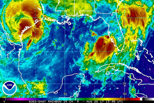
southeast Texas, as Tropical Storm Harvey
punished the area with record-shredding rainfall. As of 6:00 pm CDT
Sunday, Harvey was centered about 10 miles northeast of Victoria, TX,
moving southeast toward the coast at a mere 3 mph with top sustained
winds of 40 mph. Despite its minimal tropical-storm-strength winds,
Harvey is a superpowered rain producer. Parts of the Houston area have
racked up 20” or more in torrential rainbands since Saturday; another
10” – 20” or more is expected, with flooding expanding into parts of
southwest Louisiana. The National Weather Service has kept the Houston
area in a Flash Flood Emergency
since Saturday night—a truly unparalleled stretch—and a Civil Emergency
has been declared. And as if we needed any more trouble, a Tropical Storm Watch has been issued for the North Carolina coast as newly
designated Potential Tropical Cyclone 10 threatens to strike as Tropical
Storm Irma on Tuesday. Read more
~The nation’s worst flood disaster since Hurricane/Superstorm Sandy
continued to unfold late Sunday across Houston and nearby parts of
southeast Texas, as Tropical Storm Harvey
punished the area with record-shredding rainfall. As of 6:00 pm CDT
Sunday, Harvey was centered about 10 miles northeast of Victoria, TX,
moving southeast toward the coast at a mere 3 mph with top sustained
winds of 40 mph. Despite its minimal tropical-storm-strength winds,
Harvey is a superpowered rain producer. Parts of the Houston area have
racked up 20” or more in torrential rainbands since Saturday; another
10” – 20” or more is expected, with flooding expanding into parts of
southwest Louisiana. The National Weather Service has kept the Houston
area in a Flash Flood Emergency
since Saturday night—a truly unparalleled stretch—and a Civil Emergency
has been declared. And as if we needed any more trouble, a Tropical Storm Watch has been issued for the North Carolina coast as newly
designated Potential Tropical Cyclone 10 threatens to strike as Tropical
Storm Irma on Tuesday. Read more
Hurricane Harvey: How to help victims of the Texas storm ~Chron.com
Oil markets roiled as Harvey hits U.S. petroleum industry ~Ahmad Ghaddar, Reuters
~Texas is home to 5.6 million barrels per day (bpd) of refining capacity, and Louisiana has 3.3 million bpd. Over 2 million bpd of refining capacity was estimated to be offline as a result of the storm. Read more.
*
Hurricane Harvey: How to help victims of the Texas storm ~Chron.com
Oil markets roiled as Harvey hits U.S. petroleum industry ~Ahmad Ghaddar, Reuters
~Texas is home to 5.6 million barrels per day (bpd) of refining capacity, and Louisiana has 3.3 million bpd. Over 2 million bpd of refining capacity was estimated to be offline as a result of the storm. Read more.
*
Sunday, August 27, 2017
Tropical Storm Harvey: Live updates as 'catastrophic' flooding swamps Houston ~Nola.com
NWS @NWS This event is unprecedented & all impacts are unknown & beyond anything experienced. Follow orders from officials to ensure safety.#Harvey
Chief Art Acevedo @ArtAcevedo have reports of people getting into attic to escape floodwater do not do so unless you have an ax or means to break through onto your roof #Harvey
*
NWS @NWS This event is unprecedented & all impacts are unknown & beyond anything experienced. Follow orders from officials to ensure safety.
Chief Art Acevedo @ArtAcevedo have reports of people getting into attic to escape floodwater do not do so unless you have an ax or means to break through onto your roof #Harvey
*
Catastrophic, Historic Flooding Happening Now in Houston, Death Toll Rising in Harvey ~Weather Channel
~Thousands of homes are taking on water and hundreds of people are trapped and stranded in rising floodwaters across the Houston metro after Harvey dumped more than two feet of rain. More than 1,000 people have been rescued across the area so far as the death toll from Harvey rose to six.
~~Harvey Mangles Rockport, Texas: 'I've Never Seen Anything Like It'
Houston resident urged to climb to their roofs
Residents at epicenter of Harvey's landfall return to heartbreaking devastation
 @liprap Retweeted @BradDriverKHOU
~Thousands of homes are taking on water and hundreds of people are trapped and stranded in rising floodwaters across the Houston metro after Harvey dumped more than two feet of rain. More than 1,000 people have been rescued across the area so far as the death toll from Harvey rose to six.
“There is life-threatening, catastrophic flooding
happening now in Southeast Harris County,” Jeff Lindner of the Harris
County Flood Control District told The Weather Channel.
Five
people have died in the Houston area in unconfirmed flood-related
deaths as torrential rain continues to fall, according to the National
Weather Service.
 |
| Harvey from the ISS, image credit: NASA/Getty |
Houston resident urged to climb to their roofs
Residents at epicenter of Harvey's landfall return to heartbreaking devastation
The poor Waugh Ave bat colony...
Saturday, August 26, 2017
Harvey Impacts Underway in Houston, Galveston: Hundreds of Thousands Without Power ~Weather Channel
Almost 300,000 are without power and possible tornado damage was reported in cities near Houston Saturday as heavy rain and strong winds from Harvey continued to threaten the area with dangerous flooding.
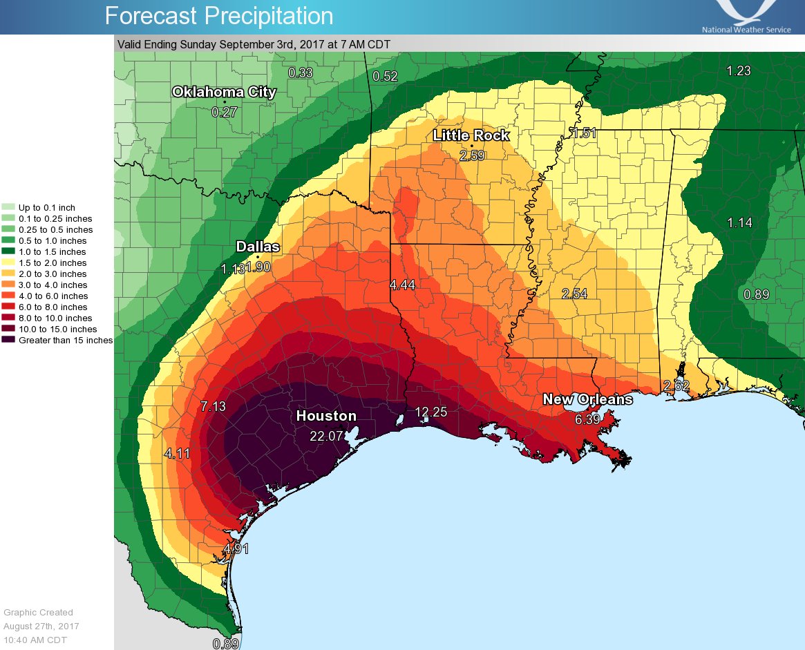
Heavy rainfall and gusty winds will persist in the Houston area through at least Monday, according to weather.com meteorologist Linda Lam. Rainfall totals of 15 to 30 inches are expected, with locally up to 40 inches possible through midweek. This amount of rainfall brings a serious concern of catastrophic and life-threatening flooding.
The storm left at least one dead in Rockport Friday night. A man was killed when his home caught on fire during the height of the storm. Read more
Almost 300,000 are without power and possible tornado damage was reported in cities near Houston Saturday as heavy rain and strong winds from Harvey continued to threaten the area with dangerous flooding.
Heavy rainfall and gusty winds will persist in the Houston area through at least Monday, according to weather.com meteorologist Linda Lam. Rainfall totals of 15 to 30 inches are expected, with locally up to 40 inches possible through midweek. This amount of rainfall brings a serious concern of catastrophic and life-threatening flooding.
The storm left at least one dead in Rockport Friday night. A man was killed when his home caught on fire during the height of the storm. Read more
Why storm experts are so scared about Hurricane Harvey’s rain ~Brian Resnik, Vox
And, it’s kind of mind-boggling. So I called up Hal Needham to help put in in perspective. Needham is a scientist (a geographer by training) and consultant who studies storm surge risk. He’s based in Galveston, Texas, and writes about storm surge science on his blog. He says when a storm like Harvey comes along, we tend to think too simply about storm risk: We fixate on wind speed, or storm surge height, or rain. But what makes this particular storm risky (and complex) is how all those elements mix together. Read more
Hurricane Harvey is a huge, life-threatening storm.
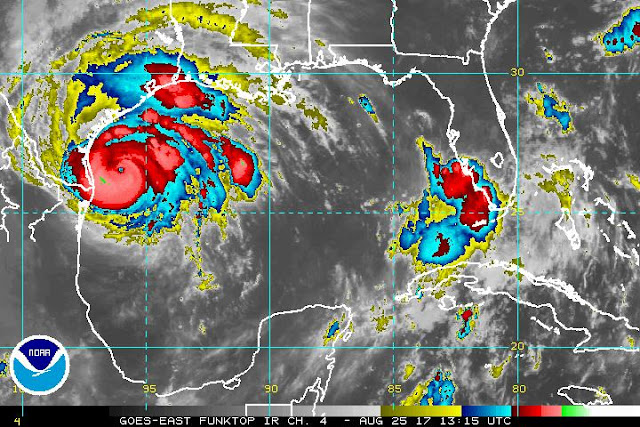
It struck the Central Texas coast Friday night and brought with it 130
mph winds and several feet of storm surge. But perhaps more concerning
is the rain still to come.
“Catastrophic and life-threatening flooding is expected
across the middle and upper Texas coast from heavy rainfall of 15 to 30
inches, with isolated amounts as high as 40 inches, through Wednesday,”
the National Hurricane Center reports in its forecast. That’s almost an entire year’s worth of rain over the course of a few days.
 | |
| Hat Tweet for above graphic: Jeffrey Ray @cbs11jeffrey |
And, it’s kind of mind-boggling. So I called up Hal Needham to help put in in perspective. Needham is a scientist (a geographer by training) and consultant who studies storm surge risk. He’s based in Galveston, Texas, and writes about storm surge science on his blog. He says when a storm like Harvey comes along, we tend to think too simply about storm risk: We fixate on wind speed, or storm surge height, or rain. But what makes this particular storm risky (and complex) is how all those elements mix together. Read more
*
Friday, August 25, 2017
Intensifying Harvey On Track to Hit Texas as Major Hurricane ~Bob Henson, Weather Underground

Sandbags are available to be picked up from 9a-5p until further notice @ Elysian Fields Ave & I-610 and Broad St & Poydras St
GCOOS: Gulf of Mexico Coastal Ocean Observing System
*
Thursday, August 24, 2017
Dangerous, Rapidly Intensifying Harvey Expected to be a Major Hurricane ~Dr. Jeff Masters, Wunderground
Now that Harvey has a well-formed structure, I don’t see any impediments to it intensifying right up until landfall. I expect Harvey will be a Category 2 hurricane by Friday morning and a Category 3 hurricane by Friday night. Harvey probably does not have enough time to become a Category 4 storm, though we cannot rule that possibility out yet.
The current favorable conditions for development will remain in place through Friday night, according to the 12Z Thursday run of the SHIPS model. Wind shear will remain light to moderate, and the atmosphere will be moist. SSTs will remain near 30°C (86°F), and warm waters will extend to considerable depth, with a total ocean heat content of 50 – 80 kilojoules per square centimeter. From Thursday night into Friday, Harvey will get an extra boost in energy as it passes over a warm-core eddy that broke off from the Loop Current. The oceanic heat content within the eddy exceeds 75 kilojoules per square centimeter, enough to support rapid intensification. However, the heat content of this eddy is not as high as the heat content available to Hurricane Katrina of 2005, when it moved over a similar warm-core eddy.
This morning’s runs of our top intensity models—the HWRF, LGEM, COAMPS-TC, and DSHIPS—all predicted a Category 2 or 3 hurricane at landfall. Read more.
*
Now that Harvey has a well-formed structure, I don’t see any impediments to it intensifying right up until landfall. I expect Harvey will be a Category 2 hurricane by Friday morning and a Category 3 hurricane by Friday night. Harvey probably does not have enough time to become a Category 4 storm, though we cannot rule that possibility out yet.
The current favorable conditions for development will remain in place through Friday night, according to the 12Z Thursday run of the SHIPS model. Wind shear will remain light to moderate, and the atmosphere will be moist. SSTs will remain near 30°C (86°F), and warm waters will extend to considerable depth, with a total ocean heat content of 50 – 80 kilojoules per square centimeter. From Thursday night into Friday, Harvey will get an extra boost in energy as it passes over a warm-core eddy that broke off from the Loop Current. The oceanic heat content within the eddy exceeds 75 kilojoules per square centimeter, enough to support rapid intensification. However, the heat content of this eddy is not as high as the heat content available to Hurricane Katrina of 2005, when it moved over a similar warm-core eddy.
This morning’s runs of our top intensity models—the HWRF, LGEM, COAMPS-TC, and DSHIPS—all predicted a Category 2 or 3 hurricane at landfall. Read more.
 |
| Tropical Storm Harvey as seen by the GOES-16 satellite at 10:15 am CDT Thursday, August 24, 2017. Image credit: NOAA/CIRA/RAMMB. NOAA’s GOES-16 satellite has not been declared operational and its data are preliminary and undergoing testing |
Tuesday, May 2, 2017
Wednesday, March 29, 2017
Wednesday, March 1, 2017
Thursday, February 23, 2017
Wednesday, February 8, 2017
Tuesday, February 7, 2017
Sunday, January 29, 2017
Wednesday, January 25, 2017
Monday, January 23, 2017
Major expansion of surveillance cameras in French Quarter, 20 hot spots plus new 3 a.m. rule for bars ~Jeff Adelson, N.O. Advocate
Louisiana police chief pushes ‘Blue Lives Matter’ law to make resisting arrest a felony ‘hate crime’ ~Erin Corbett, Raw Story
To Fight Coastal Damage, Louisiana Parishes Pushed To Sue Energy Industry ~Tegan Wendland, WWNO
Coyote wanders onto Frenchmen Street, seeks refuge at Dat Dog ~Wilborn P. Nobles III
Louisiana police chief pushes ‘Blue Lives Matter’ law to make resisting arrest a felony ‘hate crime’ ~Erin Corbett, Raw Story
To Fight Coastal Damage, Louisiana Parishes Pushed To Sue Energy Industry ~Tegan Wendland, WWNO
Coyote wanders onto Frenchmen Street, seeks refuge at Dat Dog ~Wilborn P. Nobles III
Thursday, January 19, 2017
Wednesday, January 18, 2017
Sunday, January 15, 2017
Friday, January 13, 2017
Thursday, January 12, 2017
Friday, January 6, 2017
Wednesday, December 28, 2016
Tuesday, December 27, 2016
Sunday, December 25, 2016
Wednesday, December 21, 2016
The Big E: Emeril Lagasse ~Brett Martin, Garden & Gun~Before the TV shows, the cookware, “Bam!,” and the rest, Emeril
Lagasse was a young chef taking over the venerable Commander’s Palace,
the launching pad for a career that would change the food world forever.
Now, with his first new New Orleans spot in nearly two decades, he’s
back to doing what he really loves
Monday, December 19, 2016
Tuesday, December 13, 2016
Sunday, November 27, 2016
Friday, November 25, 2016
The veins of America: Stunning map shows every river basin in the US ~Daily Mail
 | ||||
| Created by Imgur user Fejetlenfej , a geographer and GIS analyst with a ‘lifelong passion for beautiful maps,’ it highlights the massive expanse of river basins across the country – in particular, those which feed the Mississippi River, in pink |
Wednesday, November 23, 2016
Thursday, November 10, 2016
Friday, October 28, 2016
Wednesday, October 26, 2016
Thursday, October 6, 2016
Monday, October 3, 2016
Sunday, October 2, 2016
North Rampart streetcars finally a go: Riders to board new line on Sunday ~Jessica Williams, N.O. Advocate
Volunteers gather to rebuild homes across NOLA~WWLTV
Piedmont Wind Symphony getting a jump on Mardi Gras ~Lynn Felder, Winston-Salem Journal
Music Box Village, NOLA's most unique music venue opens ~Doug MacCash
Volunteers gather to rebuild homes across NOLA~WWLTV
Piedmont Wind Symphony getting a jump on Mardi Gras ~Lynn Felder, Winston-Salem Journal
“New Orleans was the most musically vibrant city in the country at that time. You could go see a different opera seven days a week, even on Sunday,” ~Mathew Troy, music director.
Music Box Village, NOLA's most unique music venue opens ~Doug MacCash
Thursday, September 29, 2016
Saturday, September 24, 2016
Tuesday, September 20, 2016
Sunday, September 18, 2016
Friday, September 16, 2016
Tuesday, September 13, 2016
Saturday, September 10, 2016
Thursday, September 8, 2016
Tuesday, September 6, 2016
Saturday, August 27, 2016
Wednesday, August 24, 2016
Monday, August 22, 2016
Saturday, August 20, 2016
Saturday Odds & Sods: Here Comes The Flood ~Peter Adrastos, First Draft
~It’s been an exhausting few weeks in the Gret Stet of Louisiana. Everyone I’ve heard from in the flood zone is okay but thousands of people are not. I’m proud that many of my friends are helping. We take care of our own here in Louisiana but we need all the help we can get. If you haven’t already done so please click on this link to see a few ways you can help. Your reward is a musical interlude from the Boss: read more
How Climate Change Will Redraw Louisiana’s Flood Maps ~Chelsea Leu, Wired
As The Floodwaters Subside, Rebuilding Begins. How To Prepare Before Returning Home ~Jason Saul, WWNO
~It’s been an exhausting few weeks in the Gret Stet of Louisiana. Everyone I’ve heard from in the flood zone is okay but thousands of people are not. I’m proud that many of my friends are helping. We take care of our own here in Louisiana but we need all the help we can get. If you haven’t already done so please click on this link to see a few ways you can help. Your reward is a musical interlude from the Boss: read more
How Climate Change Will Redraw Louisiana’s Flood Maps ~Chelsea Leu, Wired
As The Floodwaters Subside, Rebuilding Begins. How To Prepare Before Returning Home ~Jason Saul, WWNO
Friday, August 19, 2016
Thursday, August 18, 2016
Wednesday, August 17, 2016
Tuesday, August 16, 2016
Monday, August 15, 2016
Federal government agrees to assist Louisiana, Gov. John Bel Edwards says 20,000 rescued in historic flooding ~Advocate
~Interactive map: See Baton Rouge areas hit hardest by historic flooding over the weekend
~Hat Tweet~ Gov John Bel Edwards @LouisianaGov If your parish is not currently in the federal declaration, you can still register with FEMA, but only by phone→ 1-800-621-3362#lawx #lagov
 |
| Hat tweet @jwilliamsNOLA Ways to help flood victims in Baton Rouge, elsewhere across Louisiana via @theadvocatebr |
~Hat Tweet~ Gov John Bel Edwards @LouisianaGov If your parish is not currently in the federal declaration, you can still register with FEMA, but only by phone→ 1-800-621-3362
Sunday, August 14, 2016
Friday, August 12, 2016
Monday, August 8, 2016
Saturday, August 6, 2016
Thursday, August 4, 2016
Friday, July 29, 2016
Wednesday, July 27, 2016
Saturday, July 23, 2016
Wednesday, July 20, 2016
Monday, July 18, 2016
Wednesday, July 13, 2016
Tuesday, July 12, 2016
Sunday, July 10, 2016
Friday, July 1, 2016
Tuesday, June 28, 2016
Saturday, June 25, 2016
"Hey, Tidy, whada'ya in for?" "Me? *Artifyin." Are those painted electrical boxes outlaw art? ~Doug MacCash
~Tidy claims she had an informal hand-shake arrangement with the former
Public Works director when she started the project in 2010, and she is a
bit bewildered that municipal leaders allowed 104 of the city's
electrical boxes to be *artified*, as she puts it, without official okay
up to this point.
 |
| An electrical equipment box painted by artist Jessica Normington (Photo courtesy Jessica Normington). |
Thursday, June 23, 2016
Happy 3rd of July at City Park!
Happy 3rd of July
Happy 3rd of July
Happy 3rd of July
Happy 3rd of July
Happy 3rd of July
Wednesday, June 22, 2016
Wednesday, June 15, 2016
Tuesday, June 14, 2016
The Maps are not the Problem: In Perpetuating a Myth, Horowitz Misses the Key Point ~Dr. Ezra Boyd, DisasterMap.net
~Andy Horowitz’s recent New York Times opinion piece on the new flood insurance rate maps for New Orleans contains a number of inaccurate statements, fails to address the fundamental issue, and amounts to nothing more than picking on the “cash-strapped New Orleanians” as they continue the long process of recovering from catastrophic levee failures that occurred over a decade ago. Many of the shortcomings of this piece have been pointed out here and here. In addition to the factual errors that these critiques raise, Prof. Horowitz perpetuates a fundamental misunderstanding of flood risk and how our nation manages it. In no way do the new maps suggest that flood risk has been eliminated, as Prof. Horowitz claims. In perpetuating this inaccurate cliche, the article dances around but does not directly address a fundamental flaw in the National Flood Insurance Program.
~Andy Horowitz’s recent New York Times opinion piece on the new flood insurance rate maps for New Orleans contains a number of inaccurate statements, fails to address the fundamental issue, and amounts to nothing more than picking on the “cash-strapped New Orleanians” as they continue the long process of recovering from catastrophic levee failures that occurred over a decade ago. Many of the shortcomings of this piece have been pointed out here and here. In addition to the factual errors that these critiques raise, Prof. Horowitz perpetuates a fundamental misunderstanding of flood risk and how our nation manages it. In no way do the new maps suggest that flood risk has been eliminated, as Prof. Horowitz claims. In perpetuating this inaccurate cliche, the article dances around but does not directly address a fundamental flaw in the National Flood Insurance Program.
Friday, June 10, 2016
Thursday, June 9, 2016
Tuesday, June 7, 2016
Monday, June 6, 2016
Sunday, June 5, 2016
Friday, June 3, 2016
Friday, May 27, 2016
Thursday, May 26, 2016
Monday, May 23, 2016
Friday, May 20, 2016
Thursday, May 19, 2016
Mosquito control officials say New Orleans actively fending off the Zika virus ~Bob Marshall, The Lens
Arpents, Ligas, and Acres ~Richard Campanella, Know Louisiana
Arpents, Ligas, and Acres ~Richard Campanella, Know Louisiana
 |
| Google Earth image of False River area showing French long lots, American township-and-range, and English metes-and-bounds at upper right. Courtesy of Richard Campanella |
Wednesday, May 18, 2016
Monday, May 16, 2016
Wednesday, May 11, 2016
Wednesday, May 4, 2016
Tuesday, May 3, 2016
Subscribe to:
Posts (Atom)